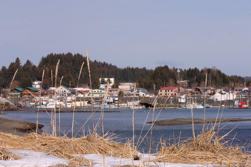
Seldovia.
Seldovia is a small community on the south side of Kachemak Bay, reached by sea or air rather than by driving from Homer. Harbour activity, wooded slopes and a surviving stretch of historic boardwalk give it a very different rhythm from a highway stop. It rewards a slow visit centred on local culture and the shore.
Photo credits1
- Depicts: SeldoviaSeldovia. Author: AlaskaTrekker at English Wikipedia. Credit: Transferred from en.wikipedia to Commons.. License: CC BY 2.5 (https://creativecommons.org/licenses/by/2.5). Source: https://commons.wikimedia.org/wiki/File:Seldovia.jpgCropped to fit the display.
Make your way to Seldovia
Choose a tool and your dates to check the options for your trip.
More ways to explore
- Country
- United States
- Currency
- USD
- Time zone
- America/Anchorage
Seldovia is a small community on the south side of Kachemak Bay, reached by sea or air rather than by driving from Homer. Harbour activity, wooded slopes and a surviving stretch of historic boardwalk give it a very different rhythm from a highway stop. It rewards a slow visit centred on local culture and the shore.
Keep the geography clear when planning: central Seldovia, Outside Beach and the roads toward Jakolof Bay are distinct parts of an outing. A town walk fits a short visit, while a forest trail or remote cabin needs more time and a reliable return arrangement. The community’s living Alaska Native heritage deserves as much attention as its picturesque waterfront.
When to go
Summer offers the broadest visitor programme. On 29 October 2026, Seldovia Bay Ferry announced its 2026 season had ended and expected 2027 bookings to open in March 2027; this is not a winter sailing schedule. The tribal museum lists regular summer opening and visits by request during normal weekday business hours in the rest of the year. Arrange winter transport, lodging and cultural visits together.
Getting there
Choose between available air services, water taxis and the appropriate ferry operator for your dates. Alaska Marine Highway lists its public dock on Dock Street in central Seldovia. Seldovia Bay Ferry is a separate passenger and light-freight service, with its Homer boarding point at Ramp 7, Dock JJ, rather than the Homer state-ferry terminal. Do not rely on a generic daily-service description after its seasonal closure.
Getting around
The central settlement suits walking, with local rental options for bicycles and golf carts when available. A farther road outing is different from exploring Main Street: confirm permitted routes, surface conditions and your return time with the rental provider. Carrying equipment across the bay also needs prior agreement with the boat operator. A water taxi landing in Jakolof Bay is not automatically a transfer into central Seldovia.
Local food
Seldovia’s small dining selection includes casual dishes such as fish tacos, sandwiches, pizza and salads, with groceries useful for a picnic or a self-catering stay. Local berry preserves provide another connection to the area’s food traditions; the Tribe also presents seafood chowder in its cultural material. Confirm meal times before a late arrival. Remote lodging may include food or require provisions, so settle that detail before boarding.
What to see
The Seldovia Village Tribe’s Visitor Center and Museum introduces the community’s diverse Indigenous and later histories through exhibits and oral-history work. Around town, look for wood carvings and the historic boardwalk; St. Nicholas Russian Orthodox Church stands on a hill nearby. The museum is a useful starting point for understanding the people behind the scenery, rather than treating buildings as disconnected photo stops.
Towns and neighbourhoods
Main Street and the small boat harbour form the practical centre for a first visit. The boardwalk and slough offer a quieter waterfront perspective, while the school area provides access to the Otterbahn Trail. Jakolof Bay is a separate destination beyond central Seldovia. If your accommodation or water taxi uses that name, establish the actual meeting point before assuming you will arrive beside the town’s cafés.
Coast and outdoors
The Otterbahn Trail passes through forest and across a salt-lagoon boardwalk to the coast. Alaska Fish and Game identifies birds, porcupines and other wildlife along the route, with bears also using the area. Its shore connection toward Outside Beach is tide-dependent; use the current tide information and remain on the trail to avoid private land. Intertidal rocks are slippery, so take suitable footwear and leave marine life undisturbed.
Where to stay
Main Street inns and waterfront rooms put the harbour and meals nearby. Cabins and lodges farther around the bay provide a quieter setting but can require additional transport. Read the property’s actual location: some chamber listings cover remote coves or even Homer. For camping, confirm the municipal park’s current facilities and seasonal arrangements rather than treating a directory entry as a live availability guarantee.
Useful before you go
Treat the waterfront as a working harbour and follow directions at loading areas. Around Kachemak Bay, strong tides, cold water and sudden weather changes can affect paddling and transfers; agree a safe plan with an experienced local operator. The Tribe’s visitor material asks people to respect beach habitats. Keep a margin before onward travel from Homer, because a short advertised crossing does not guarantee a timed connection.
Good to know before you go
Can I drive directly from Homer?
No. Seldovia is off the through-road network and is reached by boat or air.
Does the passenger ferry run throughout winter?
The operator’s notice checked on 29 October 2026 said its 2026 season had finished.
Is the tribal museum open outside summer?
Its published arrangement is by request during normal weekday business hours; contact it before visiting.
Can I walk the entire shore to Outside Beach at any tide?
No. Alaska Fish and Game identifies a tide-dependent shore section; use current tide information and the marked trail.
Do all boats use the same Homer terminal?
No. Seldovia Bay Ferry uses Ramp 7, Dock JJ in the small boat harbour, separate from the state-ferry terminal.
Sources & references
These references support the guide. Confirm opening hours, access and travel services before you go.
- 01Alaska DOT: Seldovia geography and public dock
- 02State tourism: historic core, boardwalk and church
- 03Seldovia Village Tribe: museum, heritage and seasonal access
- 04Seldovia Village Tribe: food heritage and beach stewardship
- 05Tribal ferry operator: 2026 season ended and exact terminals
- 06Chamber: separate sea and air access areas
- 07Chamber: local food choices
- 08Chamber: lodging locations and camping
- 09Local rental listing: bicycles and golf carts
- 10Alaska Fish and Game: Otterbahn habitat, access and tidal limit
- 11Alaska boating safety: local tides and changing conditions
Where could the journey go next?
More guides in United States. Compare the places and check actual connections before combining stops.
 Area near Homer
Homer
Homer faces Kachemak Bay from the southwestern Kenai Peninsula, with mountains across the water and a long spit reaching out from the town. Fishing remains central to its identity, but this is also a place for art, gardens and coastal natural history. Give the town itself some time before treating it only as a departure point for a boat trip.
Get to know the place
Haines
Haines brings a small waterfront town together with the broad Chilkat Valley and the mountain scenery of northern Lynn Canal. It is a useful place to slow down: local museums, the former military district and a harbour walk can fill a day before you add river wildlife or a longer trail. Unlike many Southeast Alaska ports, it also connects to the continental road network.
Get to know the place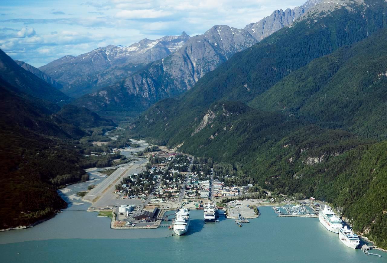
Skagway
Skagway sits at the head of Taiya Inlet, where a compact port town meets the steep approaches to White Pass. Broadway’s restored gold-rush buildings provide the familiar first impression, but the surrounding landscape tells a longer story of Tlingit trade routes, the Taiya Valley and transport between the coast and the interior. A good visit combines town history with one carefully chosen outdoor excursion.
Get to know the place Area overview: Prince of Wales Island, Alaska
Hollis
Hollis is the quiet ferry gateway on the eastern side of Prince of Wales Island, with its terminal in Clark Bay on Twelve Mile Arm. It is a small residential community with a mining and logging history, rather than a compact resort town. Forest, river and sheltered-water scenery form the setting for an arrival that often continues elsewhere on the island.
Get to know the placePhoto credits4
- Area image: View towards the ocean of St John the Baptist Catholic Church in Homer, Alaska — Area near HomerArriving at St John the Baptist Church, Homer. Author: Haydn Blackey. Credit: https://www.flickr.com/photos/haydn/48541723782/. License: CC BY-SA 2.0 (https://creativecommons.org/licenses/by-sa/2.0). Source: https://commons.wikimedia.org/wiki/File:Arriving_at_St_John_the_Baptist_Church,_Homer.jpgCropped to fit the display.
- Depicts: HainesGlaciar Davidson, Haines, Alaska, Estados Unidos, 2017-08-18, DD 75. Author: Diego Delso. Credit: Own work. License: CC BY-SA 4.0 (https://creativecommons.org/licenses/by-sa/4.0). Source: https://commons.wikimedia.org/wiki/File:Glaciar_Davidson,_Haines,_Alaska,_Estados_Unidos,_2017-08-18,_DD_75.jpgCropped to fit the display.
- Depicts: SkagwaySkagway aerial view. Author: Christopher Michel from San Francisco, USA. Credit: skagway, alaska Uploaded by Aconcagua. License: CC BY 2.0 (https://creativecommons.org/licenses/by/2.0). Source: https://commons.wikimedia.org/wiki/File:Skagway_aerial_view.jpgCropped to fit the display.
- Area image: Prince of Wales Island, Alaska — Area overview: Prince of Wales Island, AlaskaKasaan Peninsula pano. Author: Jsayre64. Credit: Own work. License: CC BY-SA 3.0 (https://creativecommons.org/licenses/by-sa/3.0). Source: https://commons.wikimedia.org/wiki/File:Kasaan_Peninsula_pano.JPGCropped to fit the display.
