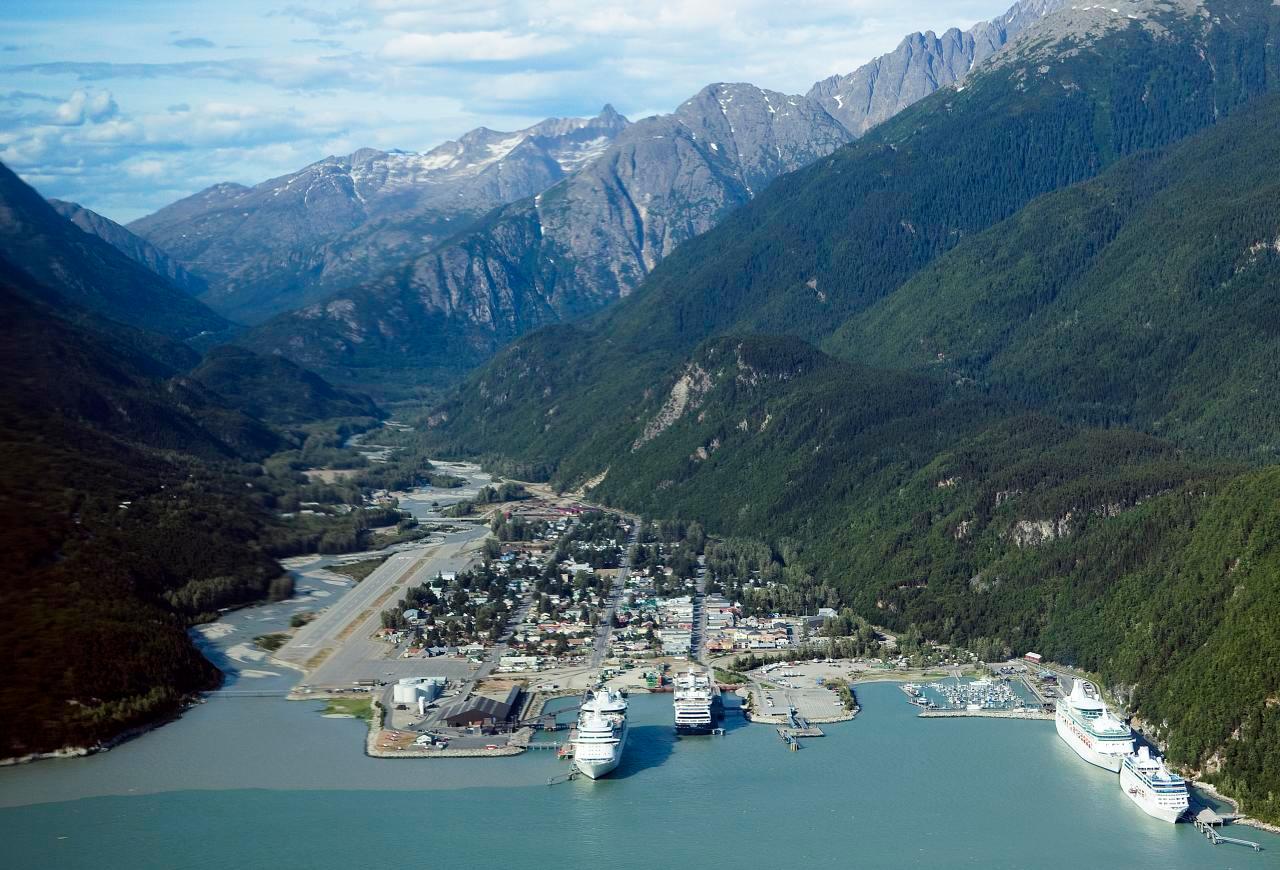
Skagway.
Skagway sits at the head of Taiya Inlet, where a compact port town meets the steep approaches to White Pass. Broadway’s restored gold-rush buildings provide the familiar first impression, but the surrounding landscape tells a longer story of Tlingit trade routes, the Taiya Valley and transport between the coast and the interior. A good visit combines town history with one carefully chosen outdoor excursion.
Photo credits1
- Depicts: SkagwaySkagway aerial view. Author: Christopher Michel from San Francisco, USA. Credit: skagway, alaska Uploaded by Aconcagua. License: CC BY 2.0 (https://creativecommons.org/licenses/by/2.0). Source: https://commons.wikimedia.org/wiki/File:Skagway_aerial_view.jpgCropped to fit the display.
Make your way to Skagway
Choose a tool and your dates to check the options for your trip.
More ways to explore
- Country
- United States
- Currency
- USD
- Time zone
- America/Juneau
Skagway sits at the head of Taiya Inlet, where a compact port town meets the steep approaches to White Pass. Broadway’s restored gold-rush buildings provide the familiar first impression, but the surrounding landscape tells a longer story of Tlingit trade routes, the Taiya Valley and transport between the coast and the interior. A good visit combines town history with one carefully chosen outdoor excursion.
The waterfront, historic centre and railway departure area are close together. Dyea is a separate valley outing, while the Klondike Highway leads toward the Canadian border and Yukon. These are different journeys: a short shore walk, a scenic railway excursion and a cross-border expedition require different amounts of time and preparation.
When to go
Summer brings the broadest choice of rail excursions, historic-building visits and transport services. The railway’s published 2026 White Pass Summit excursion season ended on 7 October; that programme does not establish winter departures. As checked on 29 October 2026, NPS described its museum’s winter access as appointment-based and the Mascot Saloon as seasonally closed. In winter, confirm indoor visits and meals before building an itinerary around them.
Getting there
Alaska Marine Highway lists its Skagway terminal at Mile 0 of the Klondike Highway, centrally located in town. Road arrivals approach via the Klondike Highway through Canada, while the visitor bureau also lists regional air and passenger-boat connections. Distinguish a state ferry, a seasonal excursion boat and a cruise dock. Confirm individual departure dates and allow time between separately booked connections.
Getting around
Walking suits much of the historic centre. SMART provides a dock-to-downtown service around cruise calls and a separate on-demand shuttle service; arrange the pickup you need rather than treating a cruise loop as universal transport. Rental cars and private transfers serve farther outings. NPS does not transport visitors to Dyea, and its road is primarily unpaved, so check road conditions before driving or cycling there.
Local food
Seafood is prominent on Skagway menus, with fish and chips among the visitor bureau’s suggested meals. Coffee shops and casual lunches fit between museum visits, and international cooking gives alternatives to an exclusively seafood-based stay. Broadway also has ice-cream and confectionery shops. Winter dining is more limited: the borough visitor bureau maintains seasonal business information and notes that some establishments take multiweek breaks.
What to see
Start with the Klondike Gold Rush National Historical Park’s historic district and visitor museum near Second Avenue and Broadway. The Mascot Saloon Museum interprets a post-gold-rush saloon, while the municipal Skagway Museum broadens the picture beyond the stampede. The White Pass railway offers mountain scenery from vintage carriages when excursions operate. Choose a particular itinerary rather than assuming every train reaches the same destination.
Towns and neighbourhoods
Broadway is the main historic visitor corridor, with parallel streets and numbered avenues making town exploration straightforward. The waterfront contains several transport facilities, so match your ticket to its actual dock. Dyea, roughly ten road miles from town, is a former boomtown in the Taiya Valley. Its archaeological remains and self-guided townsite walk reflect both the gold-rush period and the older Tlingit trading corridor.
Coast and outdoors
For a nearby coastal walk, Yakutania Point Trail begins across the Skagway River footbridge and looks over Taiya Inlet. Watch for waterbirds and harbour seals without expecting a guaranteed sighting. Lower Dewey Lake offers another outing from town; the Gold Rush Cemetery and Lower Reid Falls lie farther north. Check trail conditions and footwear before leaving the streets, especially when wet weather or early snow affects the paths.
Where to stay
Central hotels and inns around Broadway, Main Street and the numbered avenues keep museums and meals nearby. Cabins and other accommodation toward Dyea suit a quieter valley stay but require transport planning. RV parks around town are distinct from the NPS Dyea campground. The latter has limited facilities, no RV hookups and seasonal winterisation; bring drinking water and confirm its current status instead of assuming full services.
Useful before you go
The Chilkoot Trail is not an open border crossing: NPS’s 2026 guidance requires hikers to turn back at the international boundary. Overnight summer hiking has a separate permit and orientation process. The railway says no passport is needed for its specific White Pass Summit excursion, but do not extend that rule to Canadian rail or road itineraries. Check the exact route, documents, seasonal conditions and return arrangements.
Good to know before you go
Is Dyea part of downtown Skagway?
No. The historic townsite is roughly ten miles away by road in the Taiya Valley.
Can I hike through to Canada on the Chilkoot Trail?
Not under the NPS guidance checked for 2026: hikers must turn around at the international boundary.
Does every White Pass train require a passport?
The operator says its specific White Pass Summit excursion does not. Other itineraries need their own document check.
Can I walk from the state ferry to town?
The state-ferry terminal is centrally located, but confirm the particular dock and your luggage or accessibility needs.
Are museums and trains available all winter?
Do not assume so. Historic-building access and railway excursions follow different seasonal programmes.
Sources & references
These references support the guide. Confirm opening hours, access and travel services before you go.
- 01Alaska DOT: town geography and state-ferry terminal
- 02NPS: current seasonal museum access
- 03NPS: Dyea history and townsite
- 04NPS: separate local hiking areas
- 05Alaska Fish and Game: Yakutania Point wildlife and trail
- 06NPS: 2026 Chilkoot boundary closure and hiking requirements
- 07Borough visitor bureau: local dining styles
- 08Borough visitor bureau: winter restaurant closures
- 09Railway operator: specific Summit excursion and 2026 season
- 10Borough visitor bureau: distinct local transport services
- 11Borough visitor bureau: lodging locations
- 12NPS: Dyea distance, access and road conditions
- 13NPS: Dyea campground seasonal limitations
- 14Borough visitor bureau: municipal museum and local food
Where could the journey go next?
More guides in United States. Compare the places and check actual connections before combining stops.

Haines
Haines brings a small waterfront town together with the broad Chilkat Valley and the mountain scenery of northern Lynn Canal. It is a useful place to slow down: local museums, the former military district and a harbour walk can fill a day before you add river wildlife or a longer trail. Unlike many Southeast Alaska ports, it also connects to the continental road network.
Get to know the place Area overview: Prince of Wales Island, Alaska
Hollis
Hollis is the quiet ferry gateway on the eastern side of Prince of Wales Island, with its terminal in Clark Bay on Twelve Mile Arm. It is a small residential community with a mining and logging history, rather than a compact resort town. Forest, river and sheltered-water scenery form the setting for an arrival that often continues elsewhere on the island.
Get to know the place
Ketchikan
Ketchikan is an island city shaped by fishing, rainforest and the living cultures of Southeast Alaska. Its busiest waterfront faces the Tongass Narrows, with homes climbing the slopes behind it and Creek Street’s wooden buildings standing over the creek. Indigenous art and the working harbour deserve as much attention as the familiar waterfront photograph.
Get to know the place
Metlakatla
Metlakatla is a Tsimshian community on the Annette Islands Reserve, south of Ketchikan in Alaska’s Inside Passage. Fishing and seafood processing remain part of everyday life, alongside cultural work and tourism. Visit with an interest in the people who live here: this is a self-governing community, not simply an excursion backdrop.
Get to know the placePhoto credits4
- Depicts: HainesGlaciar Davidson, Haines, Alaska, Estados Unidos, 2017-08-18, DD 75. Author: Diego Delso. Credit: Own work. License: CC BY-SA 4.0 (https://creativecommons.org/licenses/by-sa/4.0). Source: https://commons.wikimedia.org/wiki/File:Glaciar_Davidson,_Haines,_Alaska,_Estados_Unidos,_2017-08-18,_DD_75.jpgCropped to fit the display.
- Area image: Prince of Wales Island, Alaska — Area overview: Prince of Wales Island, AlaskaKasaan Peninsula pano. Author: Jsayre64. Credit: Own work. License: CC BY-SA 3.0 (https://creativecommons.org/licenses/by-sa/3.0). Source: https://commons.wikimedia.org/wiki/File:Kasaan_Peninsula_pano.JPGCropped to fit the display.
- Depicts: KetchikanKetchikan, Alaska, Estados Unidos, 2017-08-16, DD 43. Author: Diego Delso. Credit: Own work. License: CC BY-SA 4.0 (https://creativecommons.org/licenses/by-sa/4.0). Source: https://commons.wikimedia.org/wiki/File:Ketchikan,_Alaska,_Estados_Unidos,_2017-08-16,_DD_43.jpgCropped to fit the display.
- Depicts: MetlakatlaView of Metlakahtla, Alaska.. Author: Unknown author Unknown author or not provided. Credit: U.S. National Archives and Records Administration. License: Public domain (https://creativecommons.org/publicdomain/mark/1.0/). Source: https://commons.wikimedia.org/wiki/File:View_of_Metlakahtla,_Alaska._-_NARA_-_297857.jpg
