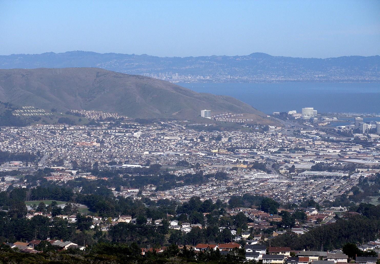
South San Francisco.
South San Francisco is a separate Peninsula city north of SFO, often called South City. Its industrial past survives in the hillside lettering above town, while biotechnology campuses shape Oyster Point. The ferry landing belongs to that bayside business district, not San Francisco’s Embarcadero or downtown waterfront.
Photo credits1
- Depicts: South San FranciscoSouthsanfrancisco. Author: Coolcaesar at English Wikipedia. Credit: Photographed on February 19, 2007 by user Coolcaesar.. License: CC BY-SA 3.0 (https://creativecommons.org/licenses/by-sa/3.0/). Source: https://commons.wikimedia.org/wiki/File:Southsanfrancisco.jpgCropped to fit the display.
Make your way to South San Francisco
Choose a tool and your dates to check the options for your trip.
More ways to explore
- Country
- United States
- Currency
- USD
- Time zone
- America/Los Angeles
South San Francisco is a separate Peninsula city north of SFO, often called South City. Its industrial past survives in the hillside lettering above town, while biotechnology campuses shape Oyster Point. The ferry landing belongs to that bayside business district, not San Francisco’s Embarcadero or downtown waterfront.
Build a visit around a shoreline walk, the local streets around Grand Avenue and a separate climb on Sign Hill. The marina and the hill offer very different landscapes. A dated transport warning matters for autumn 2026: Oyster Point Mobility reports a November ferry-terminal closure for dredging, with reopening anticipated on 1 December rather than guaranteed.
When to go
Fog can shape the bayside morning, while a hilltop and sheltered downtown street can feel different on the same day. Carry layers for exposed paths and leave an indoor history or food stop in the plan. Wildflowers and wildlife make Sign Hill interesting, but do not promise a particular seasonal sighting. Check daylight, weather and fire-related park notices before heading uphill.
Getting there
The ferry terminal is at 911 Marina Boulevard, normally serving weekday East Bay commuter journeys. As checked on 29 October 2026, Oyster Point Mobility announces November dredging closure and an expected 1 December return; confirm reopening before planning a crossing. SFO provides rail and other ground-transport options, but a flight arrival still requires a separate journey to the city or shoreline.
Getting around
Caltrain, BART, buses and local connector shuttles require a destination-specific plan. Oyster Point Mobility describes public and employer-linked services with different eligibility rules; do not assume every campus shuttle is open to visitors. During the ferry closure, use the published alternative connections. Downtown streets, the marina and Sign Hill are separate areas, so verify the last local leg and evening return.
Local food
South City’s dining reflects several communities: Mexican tortillas and tacos, Vietnamese broths, Basque meals, Italian pasta and Filipino or Pacific-inspired cooking appear in the regional visitor bureau’s listings. Grand Avenue and Linden Avenue offer alternatives to the campus dining around Oyster Point. Choose an actual menu and opening day; a commuter-oriented lunch stop may not serve the evening meal you need.
What to see
Sign Hill’s large lettering records the city’s industrial identity; the permanent concrete version dates to 1929. Designated paths offer views and help protect the surrounding habitat. The Historical Society Museum provides another way to explore the city’s past, subject to its opening programme. Oyster Point’s marina and fishing pier reveal the bayside setting, with a waterfront walk easier than a steep hill circuit.
Towns and neighbourhoods
Oyster Point concentrates the ferry, marina and many biotech workplaces. Grand Avenue and neighbouring downtown streets offer a more traditional local centre, with restaurants away from the water. The airport and conference-centre corridors serve a different purpose again. Do not confuse a South San Francisco address with a location in San Francisco itself, or assume that rail, ferry and hotel entrances share one hub.
Coast and outdoors
Oyster Point Park includes a small sandy Bay beach, picnic space and shoreline paths. It is not a Pacific surf beach; use posted conditions and water-quality information before entering the water. Sign Hill provides a separate coastal-prairie walk with habitat for the endangered mission blue butterfly. Stay on its designated trails, leave plants untouched and choose a route appropriate to the steep terrain.
Where to stay
Oyster Point can suit a waterfront or business visit, while a downtown address may place meals closer. Airport and conference-centre hotels are useful when those facilities anchor the trip. Check whether an advertised shuttle actually operates for your dates and flight times, and compare the final walk from rail or bus. A hotel’s SFO branding does not establish walking access to the airport.
Useful before you go
Sign Hill prohibits bicycles on its trails, asks visitors to keep dogs leashed and protects sensitive vegetation. Review the city’s route descriptions rather than treating every short trail as easy. At Oyster Point, respect marina and construction boundaries. Verify the November ferry closure, subsequent reopening and each connector’s calendar independently; terminal parking is not an overnight storage option.
Good to know before you go
Is South San Francisco part of downtown San Francisco?
No. It is a separate Peninsula city north of SFO, with its ferry terminal at Oyster Point.
Can I rely on the ferry during November 2026?
No. The local mobility programme reports a November closure for dredging, with return anticipated on 1 December. Confirm the latest reopening notice.
Is Sign Hill a flat waterfront walk?
No. It has hillside trails, including steep routes. Choose from the city’s trail descriptions and remain on marked paths.
Are all Oyster Point shuttles public?
No. Public connectors and employer-linked services have different access rules. Check the exact route before using it.
Sources & references
These references support the guide. Confirm opening hours, access and travel services before you go.
- 01SF Bay Ferry: South San Francisco terminal
- 02Oyster Point Mobility: November 2026 closure and expected return
- 03Oyster Point Mobility: route and connector access
- 04San Francisco Peninsula tourism bureau: South City geography and attractions
- 05San Francisco Peninsula tourism bureau: culinary communities
- 06City of South San Francisco: Sign Hill trails and habitat
- 07City of South San Francisco: historic hillside lettering
- 08San Mateo County Harbor District: Oyster Point facilities
- 09SFO: public transport
Where could the journey go next?
More guides in United States. Compare the places and check actual connections before combining stops.

San Francisco
Begin at the Embarcadero, where ferries, piers and the Bay frame an easy first walk. From there, steep streets lead to distinctive neighbourhoods, viewpoints and museums. The Ferry Building is a useful starting point, but Alcatraz departures and the Golden Gate Bridge require their own journeys.
Get to know the place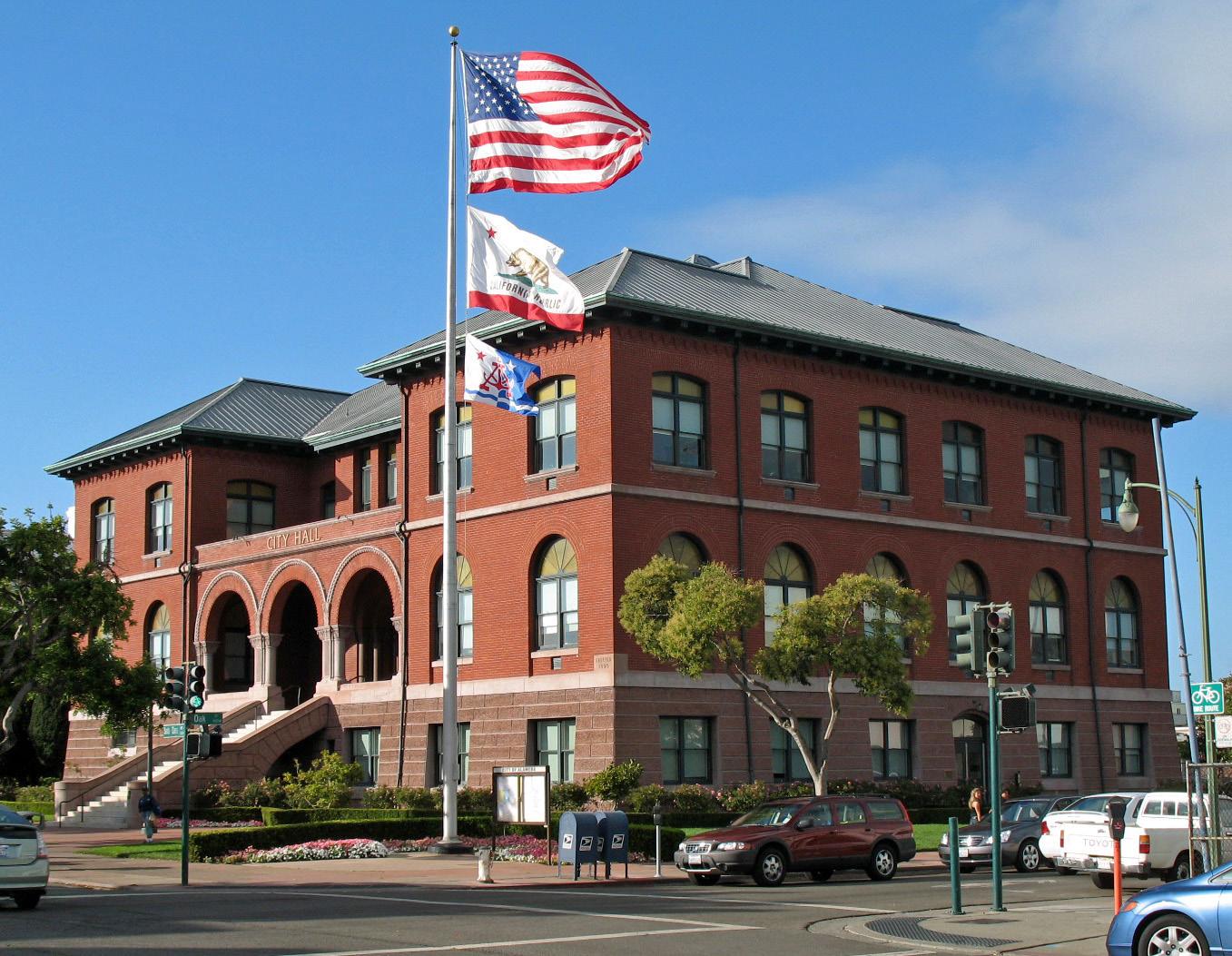 Alameda city overview — City Hall
Alameda (Harbor Bay)
Harbor Bay is Alameda’s ferry landing on Bay Farm Island, a different location from Main Street Alameda and Seaplane Lagoon. The terminal serves a waterfront neighbourhood and the nearby business area. Its setting suits a shoreline walk with views across San Francisco Bay, rather than arriving straight into Alameda’s historic shopping streets.
Get to know the placeAlameda
Alameda offers a quieter East Bay counterpoint to San Francisco: historic shopping streets, a long bayside beach and the former naval air station at Alameda Point. This is the city in San Francisco Bay, not a neighbourhood of Long Beach. Its waterfront attractions are spread across the island, so choose the part you want to explore before selecting a ferry terminal.
Get to know the place
Treasure Island, San Francisco
Treasure Island is an artificial island neighbourhood in San Francisco Bay, connected to the natural, hillier Yerba Buena Island. Created for the 1939–40 Golden Gate International Exposition, it later became a naval station. Today its historic buildings, new homes and waterfront public spaces sit within a continuing redevelopment project.
Get to know the placePhoto credits3
- Depicts: San FranciscoZeppelin-ride-020100925-195 (5029394846). Author: Craig Howell from San Carlos, CA, USA. Credit: zeppelin-ride-020100925-195. License: CC BY 2.0 (https://creativecommons.org/licenses/by/2.0). Source: https://commons.wikimedia.org/wiki/File:Zeppelin-ride-020100925-195_(5029394846).jpgCropped to fit the display.
- Area image: Alameda City Hall, Alameda, CaliforniaAlameda City Hall (Alameda, CA) 2. Author: Sanfranman59. Credit: Own work. License: CC BY-SA 3.0 (https://creativecommons.org/licenses/by-sa/3.0). Source: https://commons.wikimedia.org/wiki/File:Alameda_City_Hall_(Alameda,_CA)_2.JPGCropped to fit the display.
- Depicts: Treasure Island, San FranciscoTreasure Island Shoreline Sunset - 2025 (2). Author: 9yz. Credit: Own work. License: CC BY 4.0 (https://creativecommons.org/licenses/by/4.0). Source: https://commons.wikimedia.org/wiki/File:Treasure_Island_Shoreline_Sunset_-_2025_(2).jpgCropped to fit the display.
