
Contadora Island.
Contadora is a small island in the Pearl Islands archipelago, on Panama’s Pacific side. It combines beaches and holiday accommodation with a useful base for boat excursions. Its scale makes a quiet beach stay possible without the urban distances of Panama City, but getting there and moving luggage still need advance planning.
Photo credits1
- Depicts: Contadora IslandMain Boulevardmin Contadora. Author: Aworld196. Credit: Own work. License: CC BY-SA 4.0 (https://creativecommons.org/licenses/by-sa/4.0). Source: https://commons.wikimedia.org/wiki/File:Main_Boulevardmin_Contadora.jpgCropped to fit the display.
Make your way to Contadora Island
Choose a tool and your dates to check the options for your trip.
More ways to explore
- Country
- Panama
- Time zone
- America/Panama
Contadora is a small island in the Pearl Islands archipelago, on Panama’s Pacific side. It combines beaches and holiday accommodation with a useful base for boat excursions. Its scale makes a quiet beach stay possible without the urban distances of Panama City, but getting there and moving luggage still need advance planning.
Choose between a day trip with a fixed return and an overnight stay that leaves room for different beaches. Nearby islands are separate destinations reached by boat; they are not parts of Contadora that you can walk between. Keep excursions flexible around sea conditions rather than building the whole visit around one wildlife sighting.
When to go
The tourism authority and local accommodation describe a July–October humpback-whale season around the Pearl Islands. Sightings are wildlife encounters, never a guaranteed inclusion. Ask about responsible observation and the conditions expected on the day. A beach or birdwatching plan gives an alternative if the sea prevents an excursion; avoid tying an essential flight connection to a small-boat outing.
Getting there
Sea Las Perlas publishes departures from Flamenco Marina on Isla Flamenco, at the end of Amador. A current Contadora service page identifies the island landing at the marina on Playa Cacique. Confirm both piers with your operator because older travel pages name different locations. Air access is also advertised through private charters from Panama City’s Marcos A. Gelabert airport at Albrook; request a confirmed flight, not an assumed regular timetable.
Getting around
Walking and rented golf carts are options advertised locally. Decide based on heat, luggage and the distance between your room and beach. Ask the provider about driving rules, insurance, charging or fuel and return arrangements before taking a cart. Boat excursions require separate transport; a cart rental does not solve access to neighbouring islands.
Local food
Seafood is part of the island’s dining offer. Mar y Oro’s own restaurant page describes meals based on fish bought from local fishers, with a restaurant and beach bar at Playa Cacique. Treat this as an example of the setting, not a review or a guarantee of the daily catch. Check menus, meal times and dietary requirements directly, especially if staying in a rental house.
What to see
The appeal is primarily coastal: explore the island’s beaches, then consider a guided boat outing in the archipelago. The tourism authority highlights Pacheca for birdwatching and the surrounding islands for snorkelling and kayaking. Ask which island, landing and activity are actually included. A general Pearl Islands tour does not mean access to every beach or private property.
Towns and neighbourhoods
The airfield and Playa Galeón form one useful orientation point, while Playa Cacique is a separate beach setting with accommodation and visitor facilities. Playa Larga offers another coastal area. Choose your base by the beach and access you want, then confirm the transfer from your actual arrival point; an island address alone does not explain the walking route.
Coast and outdoors
Air Panama names Galeón beside the airport, neighbouring Playa Larga and Cacique on another side of the island. Explore according to the day’s tide, swell and local advice. Do not assume all coves have the same swimming conditions or facilities. For snorkelling, use an appropriate operator and keep clear of coral, wildlife and boat traffic.
Where to stay
Playa Cacique has beachfront accommodation, while the wider island offers small hotels and rental houses. Compare beach access with room location and meal arrangements. Confirm whether a day package includes chairs, lunch or hotel facilities, and whether an overnight booking includes arrival collection. Booking a boat ticket alone does not reserve a hotel transfer or beach-service package.
Useful before you go
Bring the identification required by the ferry and keep the return confirmation available offline. Arrange cash before leaving the mainland and confirm which payments your accommodation accepts. Check luggage rules and any handling charges with the carrier. If the island stay precedes an international flight, leave a sensible buffer for weather or transport changes rather than planning a tight same-day connection.
Good to know before you go
Which city pier serves the Contadora ferry?
Sea Las Perlas lists Flamenco Marina on Isla Flamenco, Amador. Use the exact instructions from the operator you book.
Does the ferry land beside every hotel?
No. The current service page identifies the marina at Playa Cacique. Arrange onward transport to your accommodation.
Are flights always scheduled from Tocumen?
Do not assume that. The tourism authority describes private charter access from Marcos A. Gelabert at Albrook; confirm the airport and service with the carrier.
Is a whale sighting guaranteed in season?
No. July–October is a published seasonal window, but weather and animal movements determine each outing.
Sources & references
These references support the guide. Confirm opening hours, access and travel services before you go.
- 01Panama tourism authority: Pearl Islands geography and nature activities
- 02Air Panama: Contadora beaches and charter enquiry
- 03Sea Las Perlas: current city departure and documentation
- 04Contadora service operator: Playa Cacique marina landing
- 05Contadora local travel operator: golf-cart and accommodation context
- 06Mar y Oro: own seafood restaurant description
- 07Mar y Oro: Playa Cacique location and seasonal whale context
- 08Panama tourism authority: distinct airports and private charter access
Where could the journey go next?
More guides in Panama. Compare the places and check actual connections before combining stops.
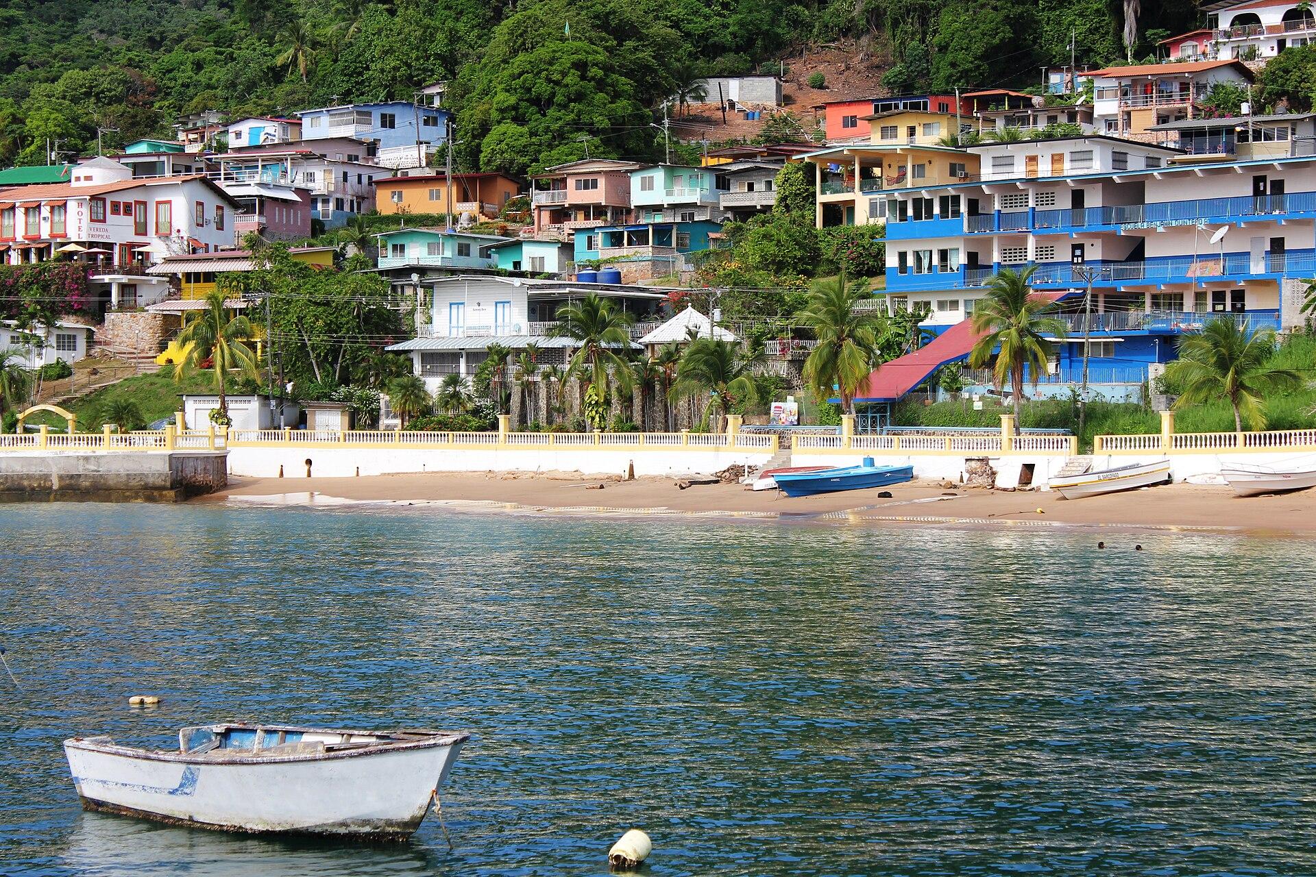
Taboga Island
Taboga is an inhabited island in the Gulf of Panama, close enough to the capital for a day trip but with its own village life. San Pedro climbs a hillside above the waterfront; narrow lanes, gardens and painted walls make a walk through the settlement part of the visit, alongside time on the sand.
Get to know the place
Panama City
Panama City brings together a modern Pacific skyline, the ruins of an earlier city and the historic streets of Casco Antiguo. It is both a destination and a transport gateway, with canal visits, urban food culture and forest walks close enough to combine over several days. Allow time for each part rather than treating the capital only as an airport stop.
Get to know the place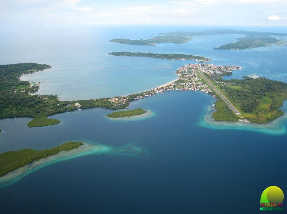 Area overview: Bocas del Toro Province
Chiriquí Grande
Chiriquí Grande is a mainland port town in Bocas del Toro province, despite the name it shares with neighbouring Chiriquí. Its value for travellers is the meeting of road and sea: arrive across the mainland, then continue by passenger boat toward Isla Colón or a prearranged stop along the coastal route.
Get to know the place Local overview of Isla Colón / Bocas Town
Isla Colón / Bocas Town
Isla Colón is the main service island of the Bocas del Toro archipelago, with Bocas Town as its lively waterfront hub. It is a practical base for restaurants, supplies and boats to neighbouring islands, but there is more to it than a transfer dock: the island also has forested areas, coastal roads and very different beach settings.
Get to know the placePhoto credits4
- Depicts: Taboga IslandTabogaBeach. Author: Ayaita. Credit: Own work. License: CC BY 3.0 (https://creativecommons.org/licenses/by/3.0). Source: https://commons.wikimedia.org/wiki/File:TabogaBeach.JPGCropped to fit the display.
- Depicts: Panama CityPanama Papers. Author: Dronepicr. Credit: Imported from 500px ( archived version ) by the Archive Team . ( detail page ). License: CC BY 3.0 (https://creativecommons.org/licenses/by/3.0). Source: https://commons.wikimedia.org/wiki/File:Panama_Papers_(148830809).jpegCropped to fit the display.
- Area image: Bocas del Toro Province — Area overview: Bocas del Toro ProvinceBocas2. Author: Panapro. Credit: Bocas TV. License: CC BY-SA 4.0 (https://creativecommons.org/licenses/by-sa/4.0). Source: https://commons.wikimedia.org/wiki/File:Bocas2.jpgCropped to fit the display.
- Area image: This is a picture of the panamanian cultural heritage monument with the ID — local overview of Isla Colón / Bocas Town.Gobernacion, Bocas del Toro, Isla Colón. Author: Charlotte Elton. Credit: Own work. License: CC BY-SA 3.0 (https://creativecommons.org/licenses/by-sa/3.0). Source: https://commons.wikimedia.org/wiki/File:Gobernacion,_Bocas_del_Toro,_Isla_Col%C3%B3n.jpgCropped to fit the display.
