
Georges Island / Boston.
Georges Island is the Boston Harbor island dominated by Fort Warren, a granite coastal fort overlooking important approaches to the city. The boat journey places Boston's waterfront in a wider setting of channels and islands. This is a destination for military history, harbour views and a picnic, not a city neighbourhood or a beach resort.
Photo credits1
- Area image: Fort Warren Gatehouse — Area near Georges Island / BostonFort Warren Gatehouse (19398180931). Author: Eric Kilby from Somerville, MA, USA. Credit: Fort Warren Gatehouse. License: CC BY-SA 2.0 (https://creativecommons.org/licenses/by-sa/2.0). Source: https://commons.wikimedia.org/wiki/File:Fort_Warren_Gatehouse_(19398180931).jpgCropped to fit the display.
Make your way to Georges Island / Boston
Choose a tool and your dates to check the options for your trip.
More ways to explore
- Country
- United States
- Currency
- USD
- Time zone
- America/New York
Georges Island is the Boston Harbor island dominated by Fort Warren, a granite coastal fort overlooking important approaches to the city. The boat journey places Boston's waterfront in a wider setting of channels and islands. This is a destination for military history, harbour views and a picnic, not a city neighbourhood or a beach resort.
Give the fort time: its parade ground, passages and later defence structures tell different parts of the story. Pair the visit with a Boston waterfront stay and reserve a suitable seasonal crossing. Georges Island in Boston is distinct from the similarly named island in Halifax, Canada, which has its own fort and transport.
When to go
Plan around the island's own calendar, not the longest season advertised for all harbour islands. The National Park Service currently lists Georges as closed for the season from 8 September. Other islands retained later public-ferry dates in 2026. Summer is the main opportunity for a staffed fort visit; ranger programmes and indoor interpretation depend on actual operations, so check a dated schedule before planning a return.
Getting there
The usual Boston public-ferry departure is Long Wharf North, with a crossing of roughly 45 minutes in the published seasonal timetable. Hingham appears in some seasonal route tables, so use the departure attached to your specific ticket rather than assuming interchangeable service. Ferries carry passengers, not cars. A national-park pass does not cover the ferry fare, and current closure information takes priority over an old timetable.
Getting around
Explore on foot using the paved exterior paths before choosing fort interiors suited to your mobility. Ground-level visitor facilities offer easier access, while parts of the fort include narrow passages, thresholds and steep stone stairs. Tide can change the slope of the boarding gangway. Ask the operator about the vessel and the park about the intended route instead of assuming the entire monument is step-free.
Local food
Bring a picnic that can travel comfortably on the ferry. The park partnership lists a Caribbean-fusion concession on Georges during the 2026 visitor season, but that seasonal listing does not establish an opening today. Long Wharf is close to downtown Boston food options before departure. Carry your own water and take every wrapper and leftover back to the mainland.
What to see
Fort Warren reflects changes in coastal defence from the nineteenth century through the World Wars. Its role included training Union troops and holding Confederate prisoners during the Civil War. Begin with the visitor centre's interpretation before exploring the structure. The visitor-centre building itself was once a mine storehouse, linking the dock to the electrically controlled harbour defences rather than merely serving as a modern arrival hall.
Towns and neighbourhoods
Think of the island as connected historic spaces: the landing and visitor centre, the broad exterior paths and picnic lawns, then the enclosed fort. The parade ground helps with orientation before entering passages or climbing to other levels. There are no shopping districts or residential quarters to navigate as a visitor. Keep your return route to the landing in mind as you explore.
Coast and outdoors
Use the island for coastal views and outdoor walking; swimming is prohibited. A picnic on the open grounds can balance time inside the fort's darker spaces. The contrast between passing ships and historic defences helps explain why this location mattered. Stay behind barriers and keep children close around changes in level rather than treating ramparts as an unrestricted climbing area.
Where to stay
Stay on the mainland for a Georges visit, choosing a Boston base with a manageable journey to the confirmed departure. The downtown waterfront is convenient for combining the ferry with other city sights. Georges has no visitor campground; the park's 2026 camping offer is on Peddocks, with separate reservations and Hingham transport. Do not plan to remain on Georges if you miss the last boat.
Useful before you go
Bring layers for the harbour breeze, comfortable footwear and a charged phone. Follow closures inside the fort and allow a buffer before boarding. Preserve historic material and natural objects where you find them, and remove all litter. Facilities are tied to staffed operating periods; an independently arranged boat does not guarantee toilets, drinking water or access to the fort during the off-season.
Good to know before you go
Is this the Georges Island in Halifax?
No. This guide is for Georges Island in Boston Harbor, Massachusetts, home to Fort Warren. Halifax's island is a separate Canadian destination.
Can I swim here?
No. Swimming is prohibited on Georges Island. Choose another suitable destination for a swimming day.
Does every part of the fort have step-free access?
No. Exterior and visitor-centre routes are easier, but some interiors have thresholds, narrow passages and steep stairs.
Can I camp on Georges?
No. The park's 2026 public camping programme is on Peddocks Island with separate arrangements.
Do all Boston Harbor Islands stay open to public ferries until October?
No. Calendars differ. The National Park Service lists Georges as closed from 8 September, while other islands had later 2026 service.
Sources & references
These references support the guide. Confirm opening hours, access and travel services before you go.
- 01National Park Service: Georges Island geography and historical context
- 02National Park Service: Fort Warren and changing coastal defence
- 03National Park Service: historic mine storehouse and dock
- 04Park partnership: fort visit, paths and swimming prohibition
- 05National Park Service: access routes and tidal gangways
- 06Park partnership: 2026 seasonal food concessions and picnic planning
- 07National Park Service: current Georges visitor-season closure
- 08Park partnership: 2026 seasonal route distinctions
- 09National Park Service: departure wharves and ferry tickets
- 10Park partnership: 2026 camping restricted to Peddocks
- 11Park partnership: carry-out policy and resource protection
- 12Park partnership: facilities depend on ferry operating hours
- 13New England Aquarium: nearby downtown transit and waterfront geography
Where could the journey go next?
More guides in United States. Compare the places and check actual connections before combining stops.

Peddocks Island
Peddocks Island offers a larger, more varied landscape than a quick city waterfront stop: wooded paths, low shore connections and the remains of Fort Andrews. It lies in Hingham Bay between Hull and Quincy. A visit combines coastal nature with military and community history, including a Portuguese fishing settlement that moved within the island as the fort developed.
Get to know the place
Spectacle Island
Spectacle Island is a Boston Harbor park island for skyline views, hillside walks and a summer beach visit. Its open landscape feels different from the granite fortifications of Georges Island. A ferry journey and a walk above the shore can make a full excursion without needing an ambitious island-hopping plan.
Get to know the place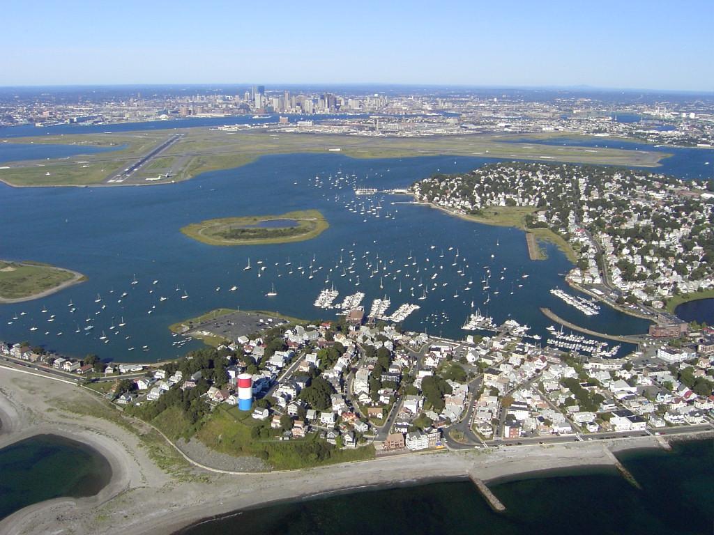
Winthrop
Winthrop is a coastal town beside Boston Harbor, with residential streets between an ocean-facing beach, sheltered water and salt marsh. The ferry landing is at the southern end on Shirley Street; it is a starting point for exploring, not the town centre or a beach resort complex. Choose a shoreline walk, local meal and one longer outdoor stop for an unhurried day.
Get to know the place
Hingham
Hingham combines a historic South Shore town centre with a harbour, a redeveloped shipyard and coastal conservation landscapes. A ferry arrival is a useful beginning, but the terminal at Hewitts Cove is not the same place as the old Main Street centre. Build the day around a few connected stops rather than assuming everything is beside the landing.
Get to know the placePhoto credits4
- Depicts: Peddocks IslandMiddle Head and East Head of Peddocks Island. Author: Doc Searls from Santa Barbara, USA. Credit: 2008_05_18_bos-sfo_022 Uploaded by Ekabhishek. License: CC BY-SA 2.0 (https://creativecommons.org/licenses/by-sa/2.0). Source: https://commons.wikimedia.org/wiki/File:Middle_Head_and_East_Head_of_Peddocks_Island.jpgCropped to fit the display.
- Depicts: Spectacle IslandSpectacle Island USGS 2013-04-15. Author: U.S. Geological Survey. Credit: Stiched from tiles acquired from https://earthexplorer.usgs.gov/ , entity IDs 2965385_19TCG345860, 2965386_19TCG345875, 2965888_19TCG360875, and 2966383_19TCG360860. License: Public domain (https://creativecommons.org/publicdomain/mark/1.0/). Source: https://commons.wikimedia.org/wiki/File:Spectacle_Island_USGS_2013-04-15.jpg
- Depicts: WinthropWinthrop ma. Author: Sean 2015 at English Wikipedia. Credit: Own work. License: Public domain (https://creativecommons.org/publicdomain/mark/1.0/). Source: https://commons.wikimedia.org/wiki/File:Winthrop_ma.jpg
- Depicts: HinghamHingham, Massachusetts. Author: Quintin Soloviev. Credit: Own work. License: CC BY 4.0 (https://creativecommons.org/licenses/by/4.0). Source: https://commons.wikimedia.org/wiki/File:Hingham,_Massachusetts.jpgCropped to fit the display.
