
Otehei Bay, Urupukapuka Island.
Otehei Bay is the ferry landing on Urupukapuka Island, where a sandy shoreline, café and walking tracks make an island day straightforward to organise. It is a separate destination from Paihia or Russell: both mainland towns are departure points across the water.
Photo credits1
- Depicts: Otehei Bay, Urupukapuka Island00 0866 Island of the Bay of Islands. Author: W. Bulach. Credit: Own work. License: CC BY-SA 4.0 (https://creativecommons.org/licenses/by-sa/4.0). Source: https://commons.wikimedia.org/wiki/File:00_0866_Island_of_the_Bay_of_Islands.jpgCropped to fit the display.
Make your way to Otehei Bay, Urupukapuka Island
Choose a tool and your dates to check the options for your trip.
More ways to explore
- Country
- New Zealand
- Currency
- NZD
- Time zone
- Pacific/Auckland
Otehei Bay is the ferry landing on Urupukapuka Island, where a sandy shoreline, café and walking tracks make an island day straightforward to organise. It is a separate destination from Paihia or Russell: both mainland towns are departure points across the water.
Beyond the landing, Urupukapuka combines regenerating forest, open pasture, archaeological landscapes and coves. Choose a short ridge walk with time on the beach, or allow a longer day to explore the track network. An overnight visit requires separate camping arrangements.
When to go
Summer brings a busier island programme and peak demand for campsites, so reserve transport and camping together. Water equipment is seasonal: the operator currently advertises daily hire returning in November 2026. Confirm the date you need instead of treating rental as a year-round service. Shorter café hours also matter for winter plans.
Getting there
Explore’s passenger ferry serves Otehei Bay from Paihia and Russell. Select the actual mainland departure and return when planning; the published timetable can change with demand. If flying to Bay of Islands Airport near Kerikeri, arrange a road transfer to your departure wharf before the sea crossing. The airport recommends prebooking taxis rather than assuming one will be available on arrival.
Getting around
On the island, walk between bays. The connected loops range from shorter routes through pasture to steeper tracks and cliff sections; close farm gates and keep to marked paths. DOC describes the complete circuit as about five hours. Choose a route that leaves enough time to regain Otehei Wharf, and supervise children closely near steep edges.
Local food
Otehei Bay Café provides the island’s organised food stop, beside the beach. Its published hours change between winter and the warmer months and can also vary with demand or weather. Carry drinking water and picnic food for a longer walk; arrange supplies before leaving the mainland rather than expecting a town grocery shop on the island.
What to see
Follow the Otehei loops for viewpoints and traces of Māori occupation, or take a longer route toward the island’s high ground. Wetland habitat around Entico Bay offers another setting for birdwatching. The complete island circuit is a substantial walk, not a quick stroll between ferry sailings. DOC currently lists the Whangapau Point Pā Track as closed after a slip; leave that branch out of your route.
Towns and neighbourhoods
Otehei gathers the wharf and café. Cable Bay, Sunset Bay and Urupukapuka Bay are separate coastal stops with designated campsites, connected by walking tracks. Entico Bay and the Akeake Peninsula lie farther into the island network. These are bays and reserve landscapes rather than neighbourhoods with shops or road transport.
Coast and outdoors
The landing beach is an easy starting point for a picnic or swim. Walk over the ridges for Cable Bay or Urupukapuka Bay, allowing for the return climb. Summer kayak and paddleboard rentals offer a different perspective, but the rental area is limited to the Otehei coastline: taking hired equipment across channels or to other islands is prohibited.
Where to stay
DOC manages campsites at Urupukapuka Bay, Cable Bay and Sunset Bay. Book a designated site separately from the ferry, then plan how to carry your equipment from the landing. Urupukapuka Bay has composting toilets and limited mobile coverage. If you prefer a room and town services, stay in Paihia or Russell and visit the island for the day.
Useful before you go
Check bags, footwear and camping equipment for pests before travel. Explore requires advance declaration of gas or fuel containers, including empty ones, and carriage remains at the skipper’s discretion. Take your rubbish back, respect nesting birds, and do not bring dogs or fly drones. The island lies within the marine mammal sanctuary: swimming within 300 metres of a marine mammal is prohibited.
Good to know before you go
Is Otehei Bay another name for Paihia?
No. Otehei is the landing on Urupukapuka Island. Paihia and Russell are mainland ferry departure points.
Does a ferry ticket include a campsite?
No. Book the DOC campsite separately and coordinate your outward and return sailings.
Can I rent a kayak and paddle to other islands?
No. The published rental boundary is the Otehei coastline, without channel crossings or visits to other islands. Hire is seasonal.
Can I walk every track shown on an old map?
No. DOC currently reports the Whangapau Point Pā Track closed after a slip. Check current track notices before choosing your route.
May I bring camping gas on the ferry?
Declare all gas and fuel containers before departure, including empty containers. Limits and the skipper’s decision apply; do not assume carriage is automatic.
Sources & references
These references support the guide. Confirm opening hours, access and travel services before you go.
- 01DOC — Urupukapuka reserve landscape and habitat
- 02Explore — Otehei landing, activities and island overview
- 03DOC — island circuit and current Whangapau Point Pā Track closure
- 04Explore — named loops, archaeology and bay connections
- 05Explore — café seasonal hours and weather caveat
- 06DOC — campsite facilities, bookings and island rules
- 07Explore — three campsites and declared dangerous goods
- 08Explore — November 2026 restart and rental area limits; conflicting frequency excluded
- 09Explore — mainland departures and timetable variation
- 10DOC — marine mammal sanctuary restrictions
- 11Bay of Islands Airport — taxi prebooking
Where could the journey go next?
More guides in New Zealand. Compare the places and check actual connections before combining stops.

Russell (Kororāreka)
Russell is compact, walkable and rich in early maritime and colonial history, but its identity is also Māori and coastal: coves, headlands and island waters frame the town.
Get to know the place
Paihia
Paihia is compact and practical for an island-rich region. The waterfront is the starting point for Russell, Urupukapuka, Cape Brett and wildlife cruises.
Get to know the place Area near Narrows (Hokianga Harbour)
Narrows (Hokianga Harbour)
The Narrows is the northern landing of the Hokianga vehicle ferry, opposite Rawene and four kilometres south of Kohukohu. It is a useful local connection on a Northland road journey, bringing travellers across a harbour with a long history of settlement and trade.
Get to know the place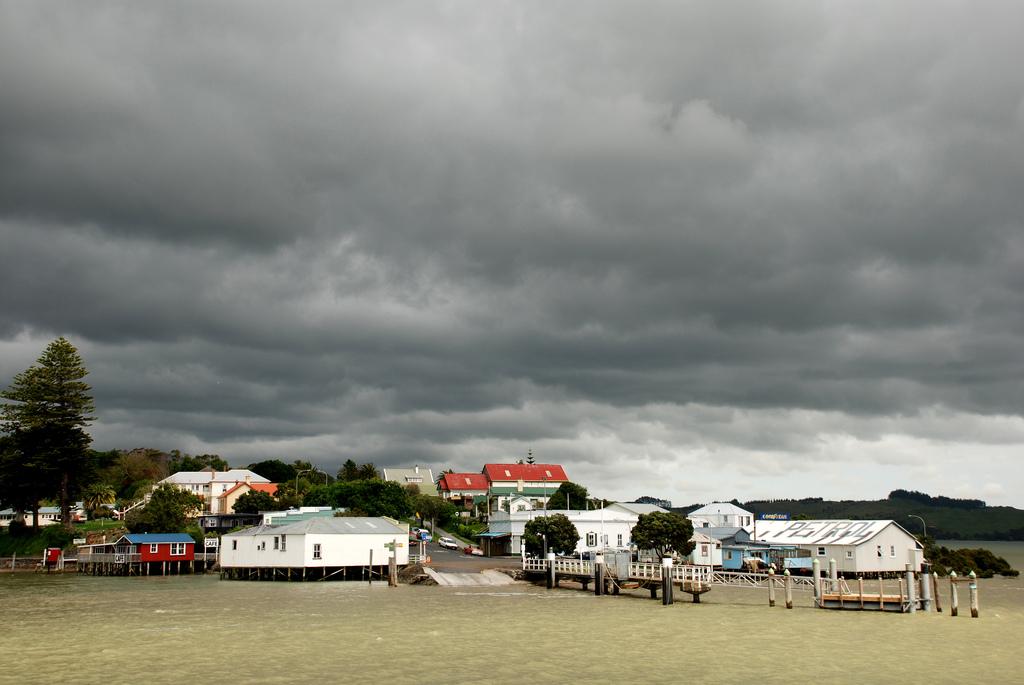
Rawene
Rawene is a small Northland village on the southern shore of Hokianga Harbour. Its waterfront, old buildings, cafés and craft culture suit travellers who prefer a slow local stay to a resort strip.
Get to know the placePhoto credits4
- Depicts: Russell (Kororāreka)1870 house in Russell. Author: Sylvain Machefert / Symac. Credit: Own work. License: CC BY-SA 3.0 (https://creativecommons.org/licenses/by-sa/3.0). Source: https://commons.wikimedia.org/wiki/File:1870_house_in_Russell.jpgCropped to fit the display.
- Depicts: PaihiaPaihia, Williams Road. Author: Ulrich Lange, Bochum, Germany. Credit: Own work. License: CC BY 3.0 (https://creativecommons.org/licenses/by/3.0). Source: https://commons.wikimedia.org/wiki/File:Paihia,_Williams_Road.jpgCropped to fit the display.
- Area image: Sail the Kohu Ra Tuarua from picturesque Rawene across the scenic Hokianga Harbour. Travel on by road through Kohukohu and Broadwood to Kaitaia, Ninety Mile Beach and fabulous Cape Reinga. Or travel south from Kohukohu, board the ferry at the Narrows and travel to Rawene, and then drive on to the beaches of Opononi and Omapere and the giant Kauris of the Waipoua Forest. — Area near Narrows (Hokianga Harbour)The Hokianga Vehicle Ferry (21234509213). Author: Bernard Spragg. NZ from Christchurch, New Zealand. Credit: The Hokianga Vehicle Ferry. License: CC0 (https://creativecommons.org/publicdomain/zero/1.0/). Source: https://commons.wikimedia.org/wiki/File:The_Hokianga_Vehicle_Ferry_(21234509213).jpg
- Depicts: RaweneRawene from the water. Author: Flickr user PhillipC / Phillip Capper. Credit: https://www.flickr.com/photos/flissphil/1596542679/. License: CC BY 2.0 (https://creativecommons.org/licenses/by/2.0). Source: https://commons.wikimedia.org/wiki/File:Rawene_from_the_water.jpgCropped to fit the display.
